Lauca National Park April 30, 2007
Posted by Jason in Chile, culture, South America.add a comment

We arrived in Arica following another lengthy over night bus journey from San Pedro, on the border with Peru. We were told that Arica was not a nice town to be in, however we found the people here friendly and the town suprisingly pleasant for a border town.
Sandwiched between the desert and the sea, we found a pristine beach totally empty with the odd pleasant cafe and bar to entertain ourselves. Trying the local Pisco Sour variation was a delight (although a little painful in the morning!)
We only intended to stay here one night but we were stranded as we arrived on a Sunday when everything was shut.
We arranged a hire car, a 4 x 2 high clearance pick up for the trip to Lauca National Park. This National Park is little visited by gringos as it takes a little more thought and time to explore. Cheryl had been looking forward to visiting here for over a year!


So we arranged a special deal for the vehicle and headed off first into the valley of Azapa to look at the Archaeological sites. Similar to Nazca and elsewhere, the pre Inca people of this area used geoglyphs on the mountainsides. Large drawings of animals and human figures drawn by moving stones, dating from around 1000 to 1400 AD.
We then drove over a desert mountain pass to Poconchile and the main road east to the border with Bolivia and the Lauca National Park. The landscape is stark desert. Nothing growing with the odd oasis and the valleys fertile following the rivers to the coast.

The road winds its way east through the desert and then through Sierra and a small area of growth of a cactus that only grows between 2,500and 2,800m, the Candelabra Cactus.
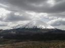
We continue into the mountains to Putre. Putre is a village that stands at 3,500m with a towering snow capped peak behind it. It is a spectacular setting and the village is quiet and quaint. Beautiful narow streets and cobbled roads. Some streets have amazing 17th Century carved stone doorways and windows. Here we stayed the night. Going from sea level to 3,500m can be a dizzy experience! So we rested for the next days drive.


The following day we travelled east towards the Bolivian border and the highest point of the Altiplano at 4,570m Lake Chungara, is apparently the highest lake in the world.
We travelled with a nice guy, Leo (Austrian), whom we had met the night before. The views were spectacular as we continued to climb from Putre and the volcanoes of Pomerape and Parinacota came into view. The area here is quite different from many areas of the altiplano that can be very arid. The moisture that comes from the Amazon arrive here and deposit rains that keep the land very fertile. There is much grazing of llamas, alpacas and sheep.


We were also lucky to sea wildlife such as vicunas (of the llama family but cannot be tamed), viscachas (like rabits with a bushy tale!) and nandu (rheas, of the ostrich family).
The landscape here is truly spectacular, high snow capped volcanoes, wildlife, a beautiful lake and isolated highland communities. We even managed to glimpse the mountain of Sajama, the highest mountain in Bolivia.
We travelled to the village of Parinacota where we had Mate de Coca. The village is very small and beautiful. At 4,392m. It is an old and dusty village with an Aymaran population that are away from the village most of the year shepherding and only return for fiestas and religious times. The population is very small.


In addition we travelled to a very remote community called Caquena on a very rough dirt road. This village like Parinacota is empty most of the year. It appears that they only keep the very young or very old at the village and everyone else is out in the mountains. It is quite spooky walking around a village that is almost deserted! The setting is quite beautiful though with the volcanoes behind.
The day was a tiring drive and we returned to Putre for a good nights rest and a few beers.
We ate in a locals restaurant with superb food, the choice being alpaca or pollo (chicken), of course we had to have alpaca which was excellent. We were then arm twisted to take part in the village raffle which everyone was very excited about. The top prize being 10 kilos of Sugar! The second prize 4 kilos!! The owner of the restaurant was very excited at the prospect of winning this so we gave our tickets to her. She was very pleased!
The following day we said goodbye to Leo and headed down another dirt road to the salt flats of Surire. A spectacular road through more deserted villages and past smoking volcanoes. The salt flats were nice, with flamingoes in abundance. We nearly got the car stuck on a pass which we had to abandon! Then settled for a bunkhouse to stay at the Guardeparque station.


The following day we had to abandon a pass we were to take as the road was almost non existant! So we retraced our steps with the intention of taking another road to some more archaeological sites, unfortunately, we got a flat tyre and decided it would be too much of a risk without another spare to hand! Some of ther “roads” around here hardly have any traffic on them at all.
We had been thinking how nice it would be to roam these lands and walk over the peaks and mountains in the area, then we came across a “mine field”!! There was a sign on this side of the mountain, but not the other! I think roaming the area might be a little too interesting at times!!
Lauca National Park was a revelation and very different from other parts of the Altiplano. We wanted to stay and climb some of the volcanoes but now time is against us and Peru is beckoning.
This northern part of Chile through the Atacama desert to Arica and Lauca National Park is very interesting and beautiful. A much better impression than further south. But now it is time for Peru!!
San Pedro and the Atacama Desert April 23, 2007
Posted by Jason in Chile, culture, South America.add a comment
The last couple of days have been a delight in one of the most hostile environments on the planet.
We finally left Argentina and headed back into Chile for the last time. This time to see the Atacama Desert.


Parts of this desert are the dryest on earth with rain only occurring every 40 years or so!! Luckily, we were stopping for a few nights at an oasis called San Pedro de Atacama.
We arrived after the usual nonsence at the border, having to open up our bags to be searched but not really searching them! A jobsworth award for somebody. The journey had been eventful too with a blow out on the Altiplano plateau at 4,500m. All good fun!
San Pedro we soon discovered is quite beautiful. Narrow dirt streets with white washed buildings. Plenty of Cafes and restaurants and ethnic music to listen to. A great place to hang out.
The first night we went to the local observatory, “Observacion Del Cielo Austral”. Where at 10pm they picked us up to be taken to a nearby area in the desert where they have 5 powerful telescopes observing the sky.
Here in the Atatacam desert is one of the best places in the world to observe the stars. Mainly clear skies all year around.
This was excellent, 3 hours of entertainment from the french scientist who runs the observatory. I now actually know how to pick out some of the constellations (click on the link constellations for more info!).
The next day we hired mountain bikes and rode out to some pre inca ruins, firstly a Pukara on a hill near to San Pedro called Pukara de Quitor (Hill fort of Quitor) and then to a site with round mud adobe houses only excavated a few years ago called Tulor 800BC. Very interesting sites.

Later in the day we took a tour of the Death and Moon Valleys and watched the sun set over the moon valley. Quite beautiful.
Sadly, we would have liked to have chilled out here a while, but another night bus awaited us to take us to Arica.
The Towers of Paine February 11, 2007
Posted by Cheryl in Chile, Patagonia, South America, Travel, trekking.1 comment so far
I’ve got to confess, I’m kinda tired of walking around for hours on end with a huge backpack on my pack, but unfortunately some things in this world can only be viewed from your feet, so it was with some trepidation that I once again donned my 20kg backpack for our jaunt around Torres Del Paine National Park ten days ago.
Torres Del Paine (appropriately named The Towers of Paine) is part of a small but spectacular mountain range in Chile. The sheer white granite towers that in some cases are topped by a black cap of softer metamorphic rock make for some pretty dramatic scenery. Our idea was to do a ten day hike right around the range which also included going up some of the valleys between the groups of mountains for a closer look.

Our first night was camped at the base of the monolithic towers of the Torres Del Paine which give the park its name. We woke at 5am for an early morning assault to the lookout an hour and a half above us for sunrise (and before the arrival of busloads of daytrippers). The sunrise was perfect – just the right amount of cloud in an otherwise clear sky and the first sun on the rocks turned them a beautiful red. The clouds above rolled in to make a moody picture. The icy wind tore at our clothes and we crouched behind rocks to take a zillion photos with the light changing every second. Eventually the need for a hot drink tore us away and we headed back to the tent, the wind clean bowling us off our feet at least once.
From the camp here (Campamento Torres) we explored further up into the Valle Del Silencio (Valley of Silence) where pretty much nobody else bothers to venture. It was equally as beautiful, perhaps more so as we had it all to ourselves. On the return to the camp, I managed to twist my ankle and could barely walk on it the next day, so we stayed here an extra night for it to recover.

The next 2 days involved walking nearly 20km a day with a heavy pack. Although there were refugios along most of the circuit where you could hire a bunk bed and buy meals, these are notoriously expensive (38 dollars for a bunk for a night!) so we were carrying our tent and as much food as we could. It still cost us 7 dollars each just to camp! My feet ached and I coveted the smaller packs of some of the daytrippers or even those carrying a lighter tent than ours – we needed five-season gear for the conditions we expected on Aconcagua, but in lesser climates I do long for a lighter tent and sleeping bag!

As we approached Refugio Dickson on the Northern side of the mountains, we were greeted with the most amazing landscape of a huge glacier in the distance across a beautiful azure lake. The campsite was on the shores of this lake and a beautiful spot. From there it was onwards and upwards towards the John Gardner Pass which is the highest point of the trek, passing the Glacier Los Perros as it calves off into a lake. The Northern side of the circuit is much quieter then the Southern side where most people hike the ‘W’ circuit, and because we were slow getting up in the morning, we mostly didn´t see anyone else all day.
The weather was pretty treacherous climbing up towards the pass at 1,241m and we had to stop and put on full waterproofs as the wind lashed rain sideways into us and made it most difficult at times to make any progress at all. It is not recommended to go over the pass in bad weather and a few times I wondered if this was bad enough weather, but we soldiered on and the view that greeted us at the top of the pass took my breath away. As you come over the pass, all you see below you is the most massive glacier stretching out below you as far as your eye can see. It was quite unbelievable – I had never seen anything like this. The sheer size of it, and the amount of ice and snow blows your mind.

For the next 2 days we walked down the side of this glacier until its snout where it calves off into Lago Grey. One night we made camp on the edge of the forest and the front door of our tent looked out onto the glacier. I couldn´t get enough of looking at it, at sunset we climbed down onto the rocks below, close to the ice and watched as it got dark, such a huge expanse of ice, constantly moving, and so powerful, it gave me renewed respect for Mother Earth or PachaMama as the South Americans call her (I love that name!).
The following night we camped at Refugio Grey which was our return to the crowds where every man and his dog come to hike the ‘W’ – one of the touristy “must-dos” of Patagonia. The campsite here was also in a beautiful spot just near to where huge chunks of icebergs that had calved off from Glacier Grey beached themselves.
The highlights on the Southern side of the park were the Cuernos Del Paine (Horns of Paine) which were equally as spectacular as the Torres, the sharp contrast between their white shafts and black tops was very striking. Also, the hike up the Valle Del Frances where it opened up into a huge cirque with incredible views of the mountains in a circle all around was very rewarding.

Although the park was very busy, and quite commercial with a few big hotels, especially on the Southern side, it wasn´t quite as bad as I had envisaged and the scenery more than made up for the amount of people. The hiking was pretty tough, and we saw a lot of people who looked like they were in even more pain than me. All in all though it was an incredible trip, but I have to say I was quite relieved to see the Hosteria Los Torres which marked the end of the circuit for us. I knew a decent meal couldn´t be far behind.
Fuegan Lamb. . . What Dreams Are Made Of. . . February 10, 2007
Posted by Jason in Chile, culture, Patagonia, South America, Travel.add a comment
Following our “interesting” cabin adventure on our ferry ride from Puerto Williams to Punta Arenas and the Magallenic Penguins, we headed off again on a 3 hour journey to Puerto Natales. Punta Arenas was ok but pretty characterless. And the weather is still decidedly chilly!
We arrived in the town of Puerto Natales, a rustic town in Chilean Patagonia, “The gateway to Torres Del Paine”.
We were lucky in that we did not book accomodation(as usual!) and were collared by a landlady when we got off the bus and she agreed to drive us to her Hospedaje – Hospedaje Milodon at Pasaje Milodon 1425 (61) – 410480.
We were pleasantly suprised as we found this a wonderful place to stay and the people who ran it were so friendly. Only $5,000 chilean (5 pounds or 10 dollars) each a night in a double with breakfast. Excellent value. I would recommend this place to anyone.
Natales is rustic and picturesque and has a nice feel to it. Quite a relaxed place to be and beautiful views at the lake side (if it isn´t raining!). You can see the edge of the southern ice cap of Patagonia (Hielo Del Sur) from here, with glaciers sweeping down from the mountains. We were lucky to have one tranquil day here where we could see the mountains and the wind finally subsided for a day and the lake was totally still. Absolutely beautiful, picture postcard stuff.
The local beers were excellent and after whetting our appetites in “The Dining Room” we found a fantastic Asado Parilla restaurant called “Le Asado Patagonicas” in the main Plaza. The amount of meat that we received was unbelievable and cooked to perfection. By far the best Parilla we have found in Chile. Although the service was somewhat “sketchy”!, the standard of the meal was superb. We had Cordero (lamb) barbecued in the traditional Patagonian way.
However, only a few days rest here as we head off to Torres Del Paine for a 10 day trek on the Grande Circuit. Can´t wait to be pounding those feet again!
Island of the Penguins February 8, 2007
Posted by Cheryl in Chile, culture, Patagonia, South America, Travel.1 comment so far

Today we visited Isla Magdalena to see the penguins. Isla Magdalena sits in the Magellan Strait about 2.5 hours ferry ride from Punta Arenas. We’ve had to wait around for an extra 2 days as there are only 3 trips a week going to the island and the one on Tuesday was cancelled.
The penguins were great. They are really cute, and worth the stormy ferry ride and the high winds on the island, which made holding the camera still while taking photos something of a challenge!
There are estimated to be 150,000 Magallenic Penguins living on the island, and it’s really impressive to see so many of them together at once.
We could have done with a little longer on the island to really enjoy them, but were only allowed an hour on the island. Not very much when you’ve done a round-trip of 5 hours just to get there!
Finally! February 8, 2007
Posted by Cheryl in Chile.1 comment so far
The photos and write up on Aconcagua have finally been completed (I just know you´ve been unable to contain yourselves waiting for them. Is anybody actually reading this apart from you Mom? Mom……….?). It´s been quite a time-consuming process, particularly on “end of the world” computers and internet connections.
Here are links to the various sets of photos on Flickr. Please see back-dated posts for Aconcagua if you haven´t found them already.
Photos 1 – Trek in to base camp
Photos 2 – Base Camp: Plaza Argentina
Photos 3 – Plaza Argentina to Camp 1
Photos 4 – Camp 1 to “The Col”
Photos 5 – “The Col” to Camp 2
The “ferry” to Punta Arenas February 5, 2007
Posted by Cheryl in Chile, culture, Patagonia, South America, Travel.add a comment
We arrived at the port in Puerto Williams on Saturday to catch our ferry to Punta Arenas. Here we found a lovely looking ship waiting in the docks, and although it looked rather more posh than what we were expecting, there were no other viable looking vessels about. So, we made a bee-line for it, already imagining the comfort of the soft upholstery on our skin and the luxury we would be sailing to Punta Arenas in!

But alas! We were turned away at the gangway and pointed in the direction of a rather lesser looking vessel some way down the coast….

“There must be some mistake” Jason protested. “Where do the people go?”.
But there was no mistake, this was the rather rickety cargo boat we had paid $170 each for the pleasure of spending the next 38 hours aboard.
Thankfully, we´d had the foresight to pay the extra $50 for a “berth” and got directed to one of only 2 private cabins tucked away in the side of the boat. It was small, and very basic, but infinitely better than the dozen or so “reclining seats” squashed into the tiny room next door.
Information on the boat was rather hard to come by (once the staff had taken our money, their only form of verbal communication was via grunting). So, after the boat set sail we spent an hour or so on the small upper “deck” watching Tierra Del Fuego float by, risking our extremities to frostbite and hoping there would soon be an announcement that dinner (all meals included) would be served. The announcement never came and we eventually slunk off to our cabin hungry.
Jason woke me at 6am as we were sailing passed an immense glacier that tumbled down the mountain directly into the Beagle Channel. This was a stretch of the route that is dubbed “Glacier Way”. Amazingly, there are only 3 ways of seeing this area and that is by
a) paying $1300 and taking a cruise liner which takes 4 or 5 days to cover much the same route, with side trips on smaller boats to the glaciers and other sites of interest. Admittedly this looks a fantastic trip, but even if we were tempted, it´s fully booked well in advance.
b) chartering a yacht which would cost a small fortune
or c) catching the “cargo” ferry (they don´t tell you this on the website! According to the Austral Broom website the ferry which services this route (Ferry Feguino) is capable of carrying a total of 284 passengers and looks nothing like the one we were on!)
Anyway, we took our chances with the ferry and were lucky enough that despite a 12 hour delay for bad weather, we still passed the glacial stretch in daylight. Up on deck, we spent the next couple of hours suffering the weather and watching a steady stream of glaciers, snowy mountains and forests slip by. This alone made suffering the 38 hours confined to bed in our small cabin (there was nowhere else to go) worthwhile.

As a result of being on deck we missed the “knock” on our cabin door to signal that breakfast was “served”, but thankfully one of the other passengers was kind enough to direct us to a tiny dining room where our breakfast was waiting or we would have missed it altogether.
From then on, every few hours (sometimes with alarming proximity to the previous meal) we would get a knock on our cabin door and find the Chilean cook outside making some rather elaborate sign language to indicate that it was time to eat again. Lunch was served at 12pm, which we thought was early, but later found out that some of the others had been called for lunch at 10.20am (less than an hour after they´d eaten breakfast!). The dining room only seated 4 people at a time, so all meals were eaten in shifts.
Needless to say, after our rather interesting journey, we were happy to arrive in Punta Arenas this morning and have booked into the Hostal al Fin del Mundo.
To Chile “Isla Navarino” and the “Dientes Circuit 5 Day Trek” February 3, 2007
Posted by Jason in Chile, Patagonia, South America, Travel, trekking.4 comments

On the 28th January 2007 we finally left Ushuaia. We found the place very welcoming and pìcturesque. Now though we wanted to see the Chilean side of Tierre Del Fuego.
Our aim was to see a bit of Puerto Williams (the most southern town in the world) and to do the Dientes Circuit trek which is billed as the most southerly trek in the world. There is always a most southern something around these parts!
Our short boat crossing to Isla Navarino was delayed due to bad weather and gale force winds, but we finally made the crossing and were picked up at Puerto Navarino by van and transported the hour and a half to Puerto Williams.
Puerto Williams is an interesting place but difficult if you have a low boredom threshold!
There is very little to do here, and as usual siesta is in full swing most of the day. This place certainly has an “end of the world” feel to it but the people are friendly.

Our most difficult objective here was to find somewhere to have a coffee or beer! Although they advertise various pubs in the “town”, we only managed to find one that was ever open! It seemed that all the gringos would end up at “Cafe Angelus” in the central plaza at some point.
After one night at an extortionately expensive Hostel we started our trek to the Dientes.
The Dientes Circuit 5 Day Trek

The Dientes (Teeth) of Navarino are the mountains that dominate the Isla Navarino and Puerto Williams. The trek was billed as a remote trek with route finding difficulties where there is a route but not always a path. Over rough terrain constantly in a mountainous landscape where the weather can be inclement at any time of the year.
We found this all to be true! We found the trek to be superb, saw no one for the whole trek and had all the wild camping spots to ourselves. We saw amazing scenery and had snow at some point on every day, even the good weather days!!
This has been undoubtedly one of the highlights of our trip so far.
Day 1 – Puerto Williams to Laguna Del Salto
Monday 29th January 2007
We had a delayed start and got a taxi to the start of the walk at a waterfall and dam.
The weather didn´t look promising, as we started uphill at 1pm with our fully laiden packs through the wooded hillside. The first section of the walk would be an easy path to follow as it goes up to a well frequented lookout on top of the mountain Cerro Bandera. I felt tired and sluggish today, my knees still creeking from previous exhertions. Cheryl though was on good form.
It soon began to rain as we put on our waterproofs and headed out of the forest towards the top of the hill. This hill has an enormous Chilean Flag on top of it, erected to remind the Argentinians who owns this part of Tierre Del Fuego!

This part of the border between Argentina and Chile is particularly sensitive. Chilean ships often patrol the Beagle Canal showing their presence to the Argentinians. Indeed the main purpose of Puerto Williams was originally the Naval Base here.
When we reached the summit the wind was howling and the temperature had dropped significantly. We headed on a bearing across the hillside towards the valley ahead to make a high traverse across scree to our first camp high up the valley at Laguna Del Salto.
As we continued the rain lashed down. We soon realised we had made our first navigational error and had to climb steadily uphill as we had traversed too low.
We had to keep above the tree line and avoid a deep ravine in order to avoid bush bashing our way for hours.
There are markers on this walk, notifying the route, however on many sections these are somewhat…..”descreet” as the lonely planet would describe! ie none existant! They use a french system of marking the route with numbers on cairns and a small map and leaflet to describe the route. In many places there is no path at all. Just directional information, route finding can be. . . . . a challenge! There are no maps of this area available.
We headed across the scree as the rain turned first to slush and then to snow. A full blown blizzard then took hold as we continued. The temperature had continued to drop and our hands were freezing. Being our usually prepared selves our waterproof gloves were at the bottom of the pack!

The blizzard stopped but the snow continued to fall. Occasionally we would get breaks in the cloud so we could see up the Valle Robajo which looked beautiful even in this weather and finally we could see our objective, the Laguna del Salto.
Reaching the end of the scree, a scree run ran down to the lake. Then we found a place to camp next to Lake Salto (480m). It took us alot longer than we thought and didn´t set up camp until about 6pm. We hoped for better weather tomorrow.
Day 2 – Laguna Del Salto to Laguna Escondida

The following day we were very tired and started late. . . again! This would be a recurring theme on this trek. It was nearly 12.30pm before we started out. The route went to the side of a stream steeply uphill to the first Pass, Paso Primero (716m). The view here was excellent. Fantastic pinnacles of rock ahead of us and snow fields.
Although it was quite cold at least we had not had any rain or snow. The wind though begins to increase as we climbed higher.

We then made our way up to Paso Australia (797m). . . . and it began to snow. Here we are in the midst of the mountains of Dientes with Laguna Del Paso below and several passes here in close proximity playing havoc with the wind. The wind is strong and we can see it blowing the snow in various different directions depending on which part of the hillside you are on.
We follow the boulder field across slope of snow around the laguna. We stop for some lunch here in what we thought was a sheltered spot out of the wind, but the wind changed direction and showered us with snow so we moved on!
Across several snow fields and scrambling across rock we reached the next pass Paso De Los Dientes (765m). The wind here was unrelenting and at times blew us both over. It blew me clean off my feet! and Cheryl hurt her wrist making it difficult to use her trekking poles.
We pass 3 more lagunas descending gradually and then head west toward Laguna De Los Dientes. Turning the corner across this plateau down to the lake proved to be somewhat difficult with the wind now so strong it was difficult to move at all across the rocky terrain.

After turning west the great Hulk of the Dientes mountains and Cerro Gabriel protected us from the wind and the sun even made a brief appearance! We rounded the next Laguna and our final climb of the day over the next pass to Laguna Escondida.

The clouds had shifted away and the sun shone through to greet us at the lake. At last peace! We pitched on the shores of the lake on its east side. It was 7pm when we reached here. We quickly pitched the tent and made our dinner. I weighed the tent down with as many rocks as I could find as we had been warned of the severe whirlwinds you can get here! Indeed through the night we had several gusts bending the tent poles a right angles!
Day 3 – Laguna Escondida to Laguna Martillo

Today it was 11.30am when we started, the earliest yet! The weather was kinder today with some sunshine and without much wind. We descended southwards and turned west into a valley and through broken forests . We could see the next pass ahead of us, Paso Ventarron (696m). We reached the top of the pass and the view was amazing. A clear day at last giving us an amazing vista. 360 degree view at the valleys and mountains. South to the Cape Horn and north to the Dientes Mountains and Cerro Ciem.
With our route clearly visible (for a change!) we traversed the scree and headed down towards the lakes in the valley and the beaver ridden landscape.

The North Amercian Beaver has took hold in Isla Navarino in a big way and devestated certain aspects of the landscape. Destroying large sections of trees near the lagunas. In some respects giving us a better view! But altering the original landscape.
We reach Paso Guerrico (572m) and pass Laguna Hermosa before descending to the beautiful Laguna Martillo.

The weather is calm, the sun is out and the view is wonderful. Monte Lindenmayer stands proud beside the lake. We have time to set up camp and have a real fire to sit round and enjoy the evening while cooking our Chorizo sausages!
Again we have the area to ourselves, just us and the Dientes mountains for company. We have not seen a sole since Cerro bandera. Wild camping in this beautiful landscape without another sole is a pleasure and a privilege. Just superb.
Day 4 – Laguna Martillo to Laguna Los Guanacos and the “Paso Virginia”

We decided to get up early today because it could be a long day route finding. So we start out at 9am.
The wind is up and we could see the clouds moving “at speed” above us. But at first the sun is still shining.

We head around the Laguna Martillo through woodland and over marsh land. We soon have trouble though and lose the path for at least half an hour. We then travel on a bearing over undulating hillsides and around lakes and find the trail again. The wind now is really picking up. Today we have to cross the highest pass of the circuit at 859m. Renowned for its difficulty with the frequency of high winds in this area. We were not to be dissappointed!

We start climbing through forest and muddy hillsides up towards the pass in the afternoon. From the speed at which the clouds were moving it must be “very” windy on top of the pass. We discussed the climb, and I suggested that by the look of the wind we may have to crawl at the top of the pass! I think Chez thought I was joking!
We reached the rocks and scree of the hillside above the tree line and now the wind was really hitting us. Throwing us over and pounding us against the mountainside. Luckily the terrain was not too difficult here and the wind was behind us.
We continued. . . . the steep mountainside began to level out as we were reaching the high pass. The pass begins to level out but continues to rise more gradually almost resembling a plateau. The consequence of this is that the wind has plenty of opportunity to hit with all its force. A large almost flat area at a high elevation for the wind to act unimpeded.
The wind as we reached the plateau was fierce. At first though it was quite funny as we let the wind drive us forward, lifting our packs. Occasional we would be picked up by the wind and dumped unceremoniously to the rocky floor.
We stopped at one point to catch our breath at a small tarn slightly sheltered from the wind.
Then we continued. The wind got stronger and stronger and now neither of us were laughing! The terain became more uneven and rocky so was difficult to keep our feet with the wind pushing us along. The wind was knocking us off our feet regularly and each time it was harder to get back up with 20Kg packs.
Eventually we got to a point where Cheryls pack came off and she simply could not get the pack back on! The wind was so fierce, and the effort to crawl without a pack was hard enough. We then foolishly decided that we would try to carry Cheryl´s pack between us. We stood up with the pack between us and the wind immediately pushed us forward, and, the pack acting as a sail the wind blew us both off the ground and dumped us down again on the rocks.
I couldn´t see Cheryl or the pack! I couldn´t move because of the wind I was pinned to the floor. It seemed along time before Cheryl finally appeared trying to walk against the wind to me.
Luckily we were both bruised but not badly hurt.
We then decided we would try to make it to the top of the pass and over the edge where hopefully we would be sheltered from the wind somewhat and I would come back for Cheryl´s pack.
Our problem now was that we did not want to be blown over the edge of the pass where there is a 300m drop! We got to the top of the pass and traversed to the east where the wind was a little less strong. I left Chez with my pack and I went back for hers.
Eventually, I made it back to the pack and made it back to Cheryl. We were both quite tired by now and were a bit shaken by the strength of the wind. The problem was that once we were committed to the pass there was little chance of retreating.
Now we scrambled down the scree slopes to the lake below. The wind subsided for a while. We expected to be sheltered from the wind but as we descended we realised that the wind was using the bowl shape of the Laguna los Guanacos to create a whirlwind effect blowing from all directions.
As we reached the Laguna shore line we hit more gale force winds coming from different directions. At one point being again knocked off our feet and my trekking pole being blown 30m up hill!

Finally we descended past the lake to the trees below and a thankfully sheltered camp site!
We later discovered that Tierre Del Fuego had suffered a familiar occurrence of bad weather on this day, haulting ferrys and causing 25m high waves on the Drake Passage to Antarctica.
Day 5 – Laguna Los Guanacos to Puerto Williams
The wind had finally died down and the sun was shining once again.
Our final day was only a few hours through forest and Calafate bushes down hill almost all the way to the road head. About a 3 hour walk.

We began the hike up the road back to Puerto Williams hoping for a lift from a vehicle along the way. We didn´t see a car for 66 minutes! Infact we saw more traffic in the air and on the sea than the road to Puerto Williams! But the car stopped and gave us a relieving lift back to town, for a shower and a beer!
Our ferry we were to catch to Punta Arena the next day was delayed and would be 12 hours over due!
The Dientes Circuit has been one of the highlights of our trip. We saw nobody for the 5 days trekking and had all the campsites to ourselves. We understand only about 300 people attempt this trek a year. The scenery is outstanding. We would recommend it to anybody. . . . . although maybe we would like to keep the secret to ourselves!


